When a natural disaster strikes or a national security emergency breaks out, every minute counts.
But it can take a satellite in low earth orbit 100 minutes to make one of the many passes needed to provide global coverage. Larger satellites can provide continuous coverage of greater areas but require higher altitudes and still only cover roughly one-third of the Earth.
In critical, fast-moving situations, space operators can find themselves challenged by the stubborn inflexibility of satellite positioning, which, despite numerous technological advances, still requires satellites to rotate or orbit into viewing range to image a target.
The Aerospace Corporation is testing a new approach that leverages atmospheric drag to provide dynamic satellite re-positioning, enabling on-demand responsiveness to emerging situations on the ground.
This new concept, known as Project Rollercoaster, is an alternative to the current, static method of satellite imaging that leverages maneuvering and the atmospheric drag of low Earth orbit (LEO) to rapidly and efficiently alter satellite ground tracks.
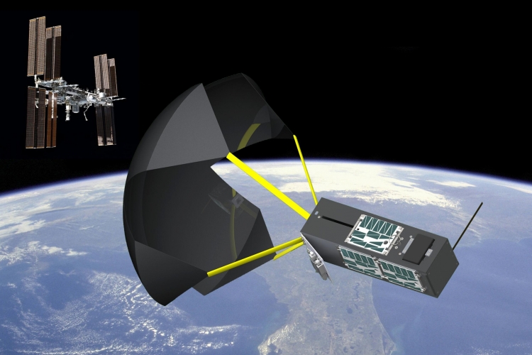
In this fictional demonstration, the Rollercoaster CONOPS is used to survey damage to San Juan after a hurricane strikes Puerto Rico. The Rollercoaster CubeSat achieves a flyby over San Juan in ~27 hours, whereas the ISS (from which it’s deployed) would not have such a viewing opportunity for tens of days.
“If you want to get eyes on the ground, this will enable you to get there in a very short timeline”, said Travis E. Swenson of Aerospace’s Flight Design and Optimization Section. “The idea is you could deploy one of these Rollercoaster vehicles, use a chute and safely change your orbit so that you could image an area of interest much more responsively than you could have otherwise”.
The Project Rollercoaster methodology is divided into three sequential phases: burn, drag, and coast.
To initiate the process, a small maneuver is executed to lower perigee which alters the satellite ground track, giving the spacecraft access to higher density atmosphere. Next, the satellite deploys panels or chutes to further modify its ground track using drag.
Lastly, the drag devices are stowed or jettisoned, and the satellite continues to orbit until the target flyover is achieved. This enables global visibility access within a significantly reduced timeframe, and with greatly reduced fuel requirements.
The technology required for Project Rollercoaster has already been demonstrated via CubeSats, and computer simulation has upheld its feasibility.
“If you want to get eyes on the ground, this will enable you to get there in a very short timeline.”
If successful, the Project Rollercoaster method could allow for prompt surveying of natural disasters, provide intelligence during a national security emergency, and serve a host of other intelligence applications.
Rollercoaster could also facilitate targeted ocean re-entry of spacecraft, substantially reducing instances of land impacts while also enabling the orbit rephrasing required to avoid spacecraft collisions.
This could ultimately enable the targeting of specific landing zones and the reduction of re-entry footprints. Aerospace’s Flight Design and Optimization Section, in collaboration with iLAB, is already exploring the application of atmospheric lift to target flyovers at specific local times, and the possibility of achieving repeated passes over a target area.
Another advantage to Project Rollercoaster is that it allows for a flexible mission architecture. For example, a number of relatively inexpensive small satellites could be stored onboard a Cygnus cargo spacecraft, orbiting in stasis until called into action to provide rapid assessments of dynamic situations.
Most importantly, Project Rollercoaster underscores the nation’s need for space assets that can respond rapidly to emergent needs, paving the way for even more control of spacecraft re-entry.
As always, Aerospace is forging new ground in this area and others, while demonstrating the feasibility of a more resilient and efficient space enterprise in the process.


