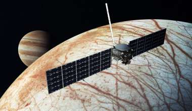
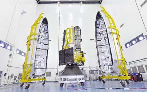
NASA and the Indian Space Research Organization (ISRO) have just launched a pioneering Earth science mission that promises to revolutionize the way the planet is monitored and understood. The joint venture, known as the NASA-ISRO Synthetic Aperture Radar (NISAR) mission, lifted off July 30 from the Satish Dhawan Space Center in Sriharikota, India, entering a near-polar orbit that will allow it to scan nearly every inch of Earth’s land and ice-covered surfaces.
A product of extensive international collaboration, NISAR brings together the technological strengths of NASA’s Jet Propulsion Laboratory (JPL) and ISRO, with critical contributions from The Aerospace Corporation. Aerospace supported the mission across multiple systems engineering and integration domains — including thermal engineering, flight operations, and system verification — to ensure NISAR delivers robust performance and reliable data that can inform scientific research, policy decisions, and environmental management around the world.
A Global Mission for a Changing Planet
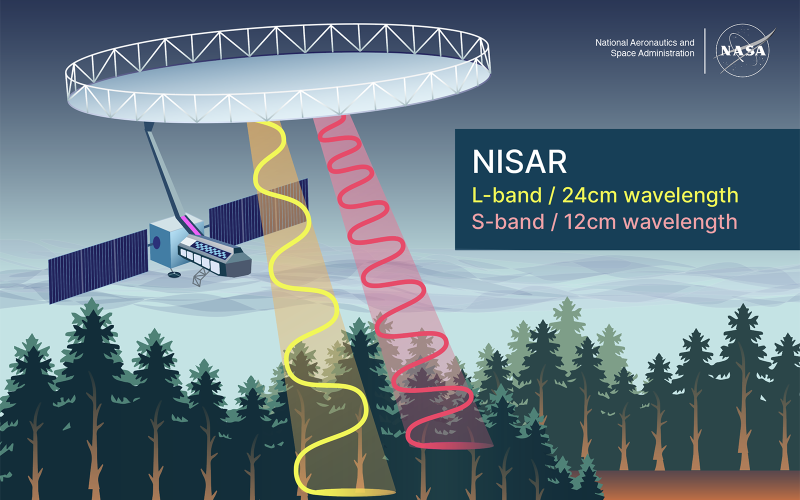
NISAR is designed to track changes in Earth’s surface with unprecedented precision, detecting movements as small as a centimeter. By using a technique called synthetic aperture radar (SAR), the spacecraft can capture extremely high-resolution images through clouds, in darkness, and in all weather conditions — making it a vital tool for consistent, year-round Earth observation. Moreover, SAR offers a major advantage over traditional optical imaging by overcoming limitations such as changing light conditions, reliably delivering detailed data regardless of the environment.
What sets NISAR apart is its dual-frequency radar system. It is the first mission of its kind to use both L-band and S-band microwaves to observe a wide array of Earth processes. These include the slow creep of glaciers, sudden jolts from earthquakes, the rise and fall of groundwater, and the health of forests and croplands. NISAR’s radar will map the planet every 12 days on ascending and descending passes, providing a global snapshot every six days over its baseline three-year mission.
With an imaging swath stretching over 150 miles (240 kilometers) wide, NISAR can comprehensively cover Earth’s surface in just under two weeks. This capability supports applications ranging from tracking the biomass of rainforests to assessing the risks of landslides and sea level rise — vital information in an era of global environmental change.
Engineering Resilience: Aerospace’s Thermal Expertise
Ensuring the reliability of NISAR’s instruments under extreme space conditions required precise thermal control. Aerospace’s thermal engineering team collaborated closely with JPL to develop and refine thermal models, integrate systems, and conduct thermal vacuum testing. Their support was essential in adapting the spacecraft’s hardware to meet stringent temperature requirements during early operations.
“Spacecraft thermal environments can be incredibly hostile, with wide swings between extreme heat and cold,” said Alexander Pagano, senior member of technical staff at Aerospace’s Thermal Control Department, and thermal engineering support lead for the NISAR mission. “My role was to make sure that NISAR’s instruments would function optimally, regardless of the conditions it encounters in orbit.”
To do this, Aerospace performed in-depth numerical analyses that led to key modifications in thermal hardware. The team also contributed to the development of a reduced reflector model for improving computational efficiency and allowing faster simulation runtimes — benefits for ongoing mission planning and operational analysis.
Aerospace support not only helped safeguard NISAR’s operational stability but also preserved the quality and accuracy of the mission’s radar data, ensuring it remains an invaluable asset for scientists and decision-makers worldwide.
Seamless Operations: From Launch to Orbit
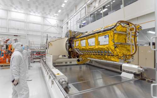
Flight operations are the beating heart of any space mission, and Aerospace’s Flight Operations Engineering team played a key role in ensuring NISAR’s successful transition from launch to orbit. The team developed and documented critical operational plans, procedures, and software tools, while also supporting mechanical systems engineering for the spacecraft’s massive radar antenna, a key component of its Earth observation capabilities.
This operational support ensured that NISAR’s systems remained aligned, calibrated, and functioning smoothly, allowing the spacecraft to begin collecting high-quality Earth observation data shortly after launch.
“NISAR will collect data on landmass, volcanoes, sea ice movement, agriculture, and any other surface feature of Earth you can think of. This data is critically important in the event of disruptive events like earthquakes and landslides, for example. With NISAR, you can pinpoint where landslides have occurred and get help to those specific areas,” said Kevin Talley, senior project engineer at Aerospace’s Systems Formulation and Implementation division, and Flight Operations Engineering support lead for the NISAR mission. “And you can now do this globally because you have the data volume and can downlink upwards of 65 terabytes a day of raw data — potentially a petabyte of data all told over the mission lifespan."
Rigorous International Testing: Verification and Validation Across Oceans
Before NISAR could deliver game-changing science, every part of the system had to pass through a gauntlet of testing and validation. Aerospace’s Verification and Validation (V&V) team worked closely with both JPL and ISRO to confirm that all mission components — from radar sensors to ground data processing systems — met rigorous safety, performance, and scientific standards.
This comprehensive approach involved teams based in both the U.S. and India and included independent requirement verification, advanced simulations, hardware-in-the-loop testing, and subsystem integration. By replicating the operational environment in testing, Aerospace ensured NISAR’s readiness for the challenges of space.
“Our goal was to identify and mitigate potential issues long before the spacecraft ever left Earth,” said Lisa Sedares, senior project engineer at Aerospace’s Global Mission Operations, and V&V lead for the L-Band SAR on the NISAR mission. “We ran through a lot of software testing and modification. Among my responsibilities were fault protection and bridging communications related to V&V between the ISRO and JPL engineers. We ensured that the goals were clearly defined, and that the systems engineers, test engineers, and software engineers had enough time and resources to meet those goals.”
Sedares noted that the collaborative nature of the mission required careful coordination between U.S. and Indian engineering teams.
“As an American systems engineer, I’m used to each team having a lead so that problems can be tackled simultaneously,” said Sedares. “In India, there’s more of a ‘hive’ approach to problem solving, in that the entire engineering team will collectively ‘swarm’ on one problem, solve it, and then move on to the next. While we had different ways of approaching problems, we aligned around a shared mission goal, and that diversity of thought made the final product better and more reliable.”
A World of Applications: From Science to Disaster Response
NISAR’s impact will extend far beyond science. Its data will empower users around the world to monitor natural hazards, manage resources, and respond to environmental crises. Whether tracking the encroachment of deserts, the retreat of glaciers, or the effects of flooding, NISAR’s radar images will be detailed enough to reveal local changes and expansive enough to detect regional trends.
Over time, this data will help researchers and policymakers better understand the forces shaping Earth’s surface. It will also inform practical applications such as water resource management, infrastructure monitoring, and disaster preparedness.
Because the mission will regularly scan some of the world’s most hazard-prone areas, it will create a rich archive of pre-disaster images. These can be used to assess the impacts of events such as earthquakes or landslides in near real-time, enabling faster and more effective response.
Crucially, all NISAR data will be openly available to the public, in line with NASA’s long-standing commitment to open science. The Alaska Satellite Facility Distributed Active Archive Center (DAAC) will host the mission’s data products, making them accessible to researchers, governments, and citizens around the globe.
A Commitment to Earth’s Future
As natural disasters and long-term climate variability intensify, the need for high-quality Earth observation data has never been greater. Missions like NISAR provide not only insights into the planet’s current state but also tools to help humanity navigate the challenges ahead.
With its powerful radar capabilities and collaborative international spirit, NISAR represents a leap forward in Earth observation—and a powerful reminder of what’s possible when nations come together in pursuit of shared goals.
“Many of us millennials or Gen Z-ers have a real concern about the planet and the environment,” said Sedares. “Apps that can track extreme weather and other events exist because of satellites collecting Earth data. Ultimately, missions like NISAR make me feel like I'm contributing to something that is going to protect people and advance understanding of the planet.”